Monday, December 26, 2016

Grand Randonnée Round-Up for 2017!

With the snow flying outside, it's time to ponder and plan your big ride(s) for 2017!

Only three US organizers have 1200k's on tap for 2017:
On the plus side, these are all veteran events, and have been touted as good first-time 1200k's. The Gold Rush and the Last Chance are the second and third oldest US 1200k's, after Boston-Montreal-Boston.

North of the border, Ontario Randonneurs is organizing their
As per their online write-up, riders will experience such features as the Niagara Escarpment, the Canadian Shield, Georgian Bay, and Lake Ontario.

Further afield, see the Randonneurs Mondiaux calendar for other 1200k and longer Grand Randonnées worldwide, 46 events in all!

Some awards for extra motivation:


The Gold Rush Randonnée, organized by the Davis Bike Club, heads north from Davis into the high plateau of NE California.  The first and final 100 miles are flat (Sacramento Valley), but there's lots of climbing and scenery in between.  Deluxe volunteer support. My report from the previous GRR (2013).


The Last Chance is rolling, open, and expansive, with panoramic views unencumbered by woods or canyons. There are some flat sections, but not as many as you'd think ("fewer flat miles than the Gold Rush"). The wind can be your constant companion. This year we are adding a foray along quiet roads into Nebraska. An evocative pioneer experience. My Photomontage (2006)


The Taste of Carolina in the fall, and Carolina Spring 1200 in the spring, vary their routes from year to year. You may get a taste of the Piedmont foothills, the Blue Ridge, and the coastal plain.  

Lots of possibilities to challenge you in 2017.  So start imagining and planning!

-jle


Sunday, December 18, 2016

Hawaii Perms

This is a compendium of routes I've developed on Maui and Hawai'i, the Big Island. They are oriented to some of the places where people might stay on vacation or live. Hawai'i is arguably the most bike-friendly island to ride, as it is roomier and has more miles of good roadway for cyclists, including the luxurious new Saddle Road (climbing over the saddle between Mauna Kea and Mauna Loa), and the busier but wide-shouldered Queen Ka'ahumanu Highway on the Kona coast. Large parts of Maui are good as well.

Many of these routes are strenuous, either because of the climbing, the wind, or the heat in the lava fields. But scenic and rewarding.

Hawaii has many faces, which makes riding there so interesting!

Click on any route name to see the RideWithGPS route.


 MAUI 

202km - 11,800 ft. climbing - 3,051 ft. max.
Lihei start

This is a tough ride, with a succession of climbs in and out of bays on the Hana Highway, and possible showers on this, the windward side;  rough pavement and some dirt on the south coast; and a climb over the shoulder of Haleakala. Can also be a hot ride in that section with limited services, but scenic and quiet! Clockwise or counter-clockwise options.

Quiet single-lane road through lava flows on Maui south coast.


 HAWAI'I (The Big Island) 

100km - 2,800 ft. climbing -  997ft. max 
Kona start

A jaunt down the coastal Queen Ka'ahumanu Highway, and climb up to Waikaloa Village, a verdant town surrounded by the dry grasses and volcano pumice of the western slope of Mauna Kea.

Grasses poke out of lava fields on the Kona Coast.

200km - 7,100 ft. climbing - 3,580 ft. max 
Kona start

Up the Queen Ka'ahumanu Highway, a stiff climb past Waikaloa Village to Waimea, and the scenic climb over the Kohala Highway to windward greenery at Hawi.

The edge of moisture on the Kohala Highway.


201km - 7,800 ft. climbing - 3,580 ft. max
Waimea start

Much like the Kona Hawi Hop, but based in Waimea, starting with the climb over Kohala Highway, and finishing with the stiff climb from the coast back to Waimea.

Climbing the Kohala Highway with sunrise over Mauna Loa.

120km - 7,500 ft. climbing - 9,117 ft. max
Waimea start

Some scenic, quiet climbing over what used to be part of the Saddle Road, to the new Saddle Road proper, and a stiff, extended climb up the Mauna Kea Road to the visitors center. Bring adequate gearing. Weather can be changeable. Typically climb through the cloud deck to the visitor center.

Looking across the cloud deck, from Mauna Kea to Mauna Loa.

101km - 5,400 ft. climbing - 6,577 ft. max
Waimea start

Same as Mauna Kea Mosey, but only to the start of the Meana Kea Road.

The rare silversword plant, outside the Mauna Kea visitors center.


100km - 5,880 ft. climbing - 3,580 ft. max
Waimea start

The Kohala Highway to the windward coast and down to scenic Pololu Lookout. Stiff climb back over Kohala Highway, which is on the division between windward (wet) and leeward (dry) conditions.

Pololu Lookout


101km - 3,900 ft. climbing - 620 ft. max
Hawi start

A visit to Pololu  Lookout and down the dry, fairly quiet northwest coast to one of the resorts and back. If you were staying at one of these resorts, the trip to Pololu Lookout and back would make a natural 100k.


A resort on the Kona Coast.

♦ ♦ 

Thoughts for Future Routes

Maui - I have thought of a "leeward side" 200k (meaning largely dry), which would take in the coast near Lihei, and West Maui at the north end of the route. Note that there can be strong winds in the "saddle" between West Maui and the other part of the island. A 100k to the top of Haleakala and back is also a natural route.

South Point on the Big Island - next stop, Antarctica.

Hawai'i - There are some possible 200km routes between Waimea and Hilo, either out-and-back, e.g., along the quiet, twisting Old Mamalahoa Highway, or taking the Saddle Road. But the Saddle Road is a prolonged, stiff climb out of Hilo (this section not yet "modernized" with shoulders), and this route has a lot of climbing. Also 100k routes from Waimea or Hilo to Waipi'o Lookout (companion to Pololu Lookout) on the coast. Some routes either from Volcano to South Point (southernmost spot in non-territorial US) or other areas of the south coast could also be good.

-jle


Tuesday, June 21, 2016

Time for the Brainard Lake Breeze 100k!

The roads are clear. The temps are welcoming at 10,000 ft. It's time to ride the refreshing Brainard Lake Breeze again!

Lefthand Canyon reconstruction between Olde Stage and James Canyon Drive is shaping up, and that stretch is open on the weekends.

Still a cliff or two left to demolish.


When this reconstruction is done, this lower section of Lefthand Canyon Drive will be more sweeping, open, and park-like. Still fun to ride, though!


When I rode this perm on Sunday, June 12, Brainard was still barricaded at the main entrance, but plowed up the road and around the lake (except for this dam of snow).


Biggest roadside snowdrifts near Niwot Cutoff Trailhead.
(But the trails are in snowshoe or posthole condition.)


A convenient place to lean your bike while having a sandwich!


* * *
Same location, May 21.


* * *
And on May 1, on skis.


Still, you could find your way around with this helpful signage.


Back then the lake was frozen and snowed over.


Enough open water for anglers by late May.


And fully open now.

* * *

A good trickle of cyclists now wend their way to Brainard for a refreshing break.
A good time to join them!

-jle


Thursday, May 26, 2016

Colorado Front Range ACP Super Randonnée

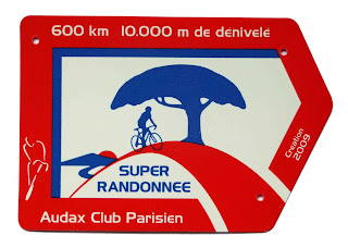
The Colorado Front Range Super Randonnée is a Permanent of slightly over 600km sanctioned by the Audax Club Parisien, and approved by the ACP in spring of 2016.

Route update as of July, 2017. 
– Ride report link added June, 2019. 

Longs Peak
The rules for this format are that the route must be at least 600km in distance, and have at least 10,000m of climbing, for which you are given 50 60 hours to complete as a Randonneur (plus one hour for each extra 500m of climbing), or about 7½ days as a Tourist.

Satellite Map

Road / Land Use Map

About Super Randonnées

ACP Super Randonnée permanents are somewhat different from RUSA permanents. If you are considering riding this or another Super Randonnée, please study the ACP rules carefully. In particular:
  • Support - No personal or official support is allowed, even at controls.
  • Control Time Limits - Intermediate controls do not have opening or closing time limits. You may, however, wish to construct a plan as to when you reach successive controls, based on climbing, sleep breaks, hours of darkness, etc.
  • Photo Control Validation - Each control (including start/finish) may be validated by taking a picture of your bike - with ACP SR frame badge affixed to it - in front of a predetermined landmark (see below). If the control is in a town, you may take a picture of your bike in front of the town line sign. Some controls have an option to validate at establishments as well. If a control provides an establishment option, you can get validation at an establishment instead of taking a photo. There are no info controls. 
  • Control Photo Timestamps - All your control photos must have either a date/timestamp embedded in the photo image (a common option on today's cameras), or as part of the DCIM information associated with digital photo files. This goes for intermediate controls as well as start and finish, and allows intermediate controls to be reused in the course of a ride (e.g., if the route is an out-and-back).
  • Randonneur vs. Tourist - You may ride the route for "Randonneur" credit (time limit of 51 hours for this route), or "Tourist" credit (successive days of at least 80km). The ACP would like to encourage the Tourist option if it suits the rider's goals - for example, it may be useful for scoping out the route to ride later as a Randonneur.
  • RUSA Credit - Riders completing this route as a Randonneur also get RUSA credit, which can be used towards awards the same as other RUSA permanents.
  • R-10000 - One reason some people may be interested in riding an SR 600k is that it's a requirement for the ACP's Randonneur 10000 award.
About the Colorado Front Range SR

The Colorado Front Range SR takes in most of the Colorado Front Range, the eastern flank of the Colorado Rocky Mountains. This terrain is well-suited for a Super Randonnée as it has lots of climbing and virtually no flat terrain. It is also scenic and somewhat remote, despite being not that far from the population centers of the Front Range. This is because the Rockies rise up in kind of a wall from the eastern plains, with a 4,000-5,000 ft. difference between the Plains and the Peak-to-Peak Highway. The route comes within six miles of the Continental Divide in the Indian Peaks Wilderness.

Mt. Toll and the Indian Peaks Wilderness from the Peak-to-Peak Highway

This is an out-and-back route. It takes St. Vrain Canyon up to the Peak-to-Peak Highway, varying between 8,000 to 9,200 ft., then through the old mining towns of Blackhawk, Central City and Idaho Springs. From there, it's up to Echo Lake and the high point of the route (11,134 ft.) on the Squaw Pass road. The southern part of the route visits the forested areas of the Rampart Range and the foothills west of Colorado Springs to reach the turnaround point in Woodland Park.


While the route has sustained altitude, it avoids the high passes and the exposed roads above timberline such as the Mt. Evans road which spurs off from Echo Lake and reaches 14, 130 ft.

Echo Lake
Despite the route's rustic and remote character, there should be ample services for the rider to support him/herself. The turnaround point in Woodland Park has stores, restaurants, and lodging. While the halfway point may not be ideal for a sleep break, this is a good candidate.

Mining Ruins near Central City
Most of the route is through National Forest land. There are no extremely steep grades, although Witter Gulch is a stiff climb, and overall the climbing can be strenuous because there's a lot of it, and less oxygen than at lower elevations.

Upper Bear Creek from the Squaw Pass Road
Because of the arid climate, nights can get quite chilly in the Rockies, down into the 30's even in summer. Plan to bring enough clothes to stay warm on descents during chilly periods. Storms can also be very chilling, so it's important to be equipped to stay dry. The sun at altitude can burn more strongly than lower down, so use sunscreen. Assess the weather forecasts carefully before setting out on a ride of this nature. Finally, as with most Super Randonnées, beware of wildlife on the road, especially at night.

Elevation Profile - first half

RideWithGPS Route (showing services, controls, climbing)
NOTE: This route has some minor inaccuracies on the segments between Black Hawk and Idaho Springs (outbound and return), corrected below.
- - -
Black Hawk to Idaho Springs (outbound)
Idaho Springs to Black Hawk (return)

OpenRunner Route (official climb-measuring tool)

Cue Sheet (showing services, elevations)

If you are interested in riding,
1. carefully review the rules,
2. contact the route owner,
3. send a signed waiver.

If you'd like to coordinate with other riders,
you are welcome to use the Colorado Rando Google Group.

This route has not yet been ridden, so veterans may be offer you valuable insights.

Ride Reports

Greg Smith, June 2019


Photo Controls

1/11 Niwot
1/11 - Niwot - Alternative photo is carvings near Niwot and 79th St.

2/10 - Lyons

2/10 - Lyons detail
2/10 Lyons - mural at visitors center


3/9 - Eldora

3/9 Eldora - town line sign (pointing west)
(This is an interesting sign, because it greets you if you've come back from the Hessie or Fourth of July Trails, or have hiked over the Continental Divide.)


4/8 - Echo Lake

4. Echo Lake - Echo Lake Lodge in background

5/7 - Brook Forest, now superseded by control at top of climb at Sandy Lane.

5/7 Brook Forest Rd. - see note above.


6. Woodland Park - This sign has disappeared as of summer, 2017.

6 - Woodland Park - Sign at Lions Park ok alternative.
Also the Country Lodge sign, south side of US-24,
where you may be taking a rest.


Some Views En Route

Indian Peaks from Peak-to-Peak Highway


 Rampart Range with Evening Rainbow

8% Grade for 4 miles, into Deckers

Rampart Range - Morning

Descending to Buffalo Creek

South Platte River with Cathedral Rocks

- jle -