I had the pleasure - and challenge! - of pre-riding Vernon Smith's Cripple Creek - Pine Junction 300k. Riders on the inaugural event last year reported splendid scenery but quite a lot of work involved, as the route has 16,780 ft. of climbing.
Here's the route:
Starting off at 4am, you climb past the tourist shops and vintage motels of a sleeping Manitou Springs and on to US-24, which has good shoulders.
It's a moderate 2000 ft. climb to Woodland Park at 8,400 ft., with dawn breaking over Pikes Peak.
On past Divide, and you've climbed to Ute Pass at 9,165 ft. before leaving US-24 ... after which you get a break ... before climbing some more.
The approach to Cripple Creek is on generally quiet, winding county roads - punctuated by little climbs - transiting the Florrisant Fossil Beds National Monument. You can see some petrified stumps as you ride by.
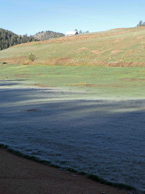
On the day I rode, there was lots of frost from Divide through Cripple Creek. Chilly cycling, but the payback was relatively temperate climbing in the afternoon. This in fact is one of the challenges of this course: higher, crispy altitudes at the cool part of the day, followed by long climbs in the hotter part.
A final climb brings you to the "lip" overlooking Cripple Creek and the first checkpoint.
Cripple Creek is nothing if not imbued in mining history.
At this time of the morning, it's still pretty quiet, the hustle and bustle of tourists and gamblers yet to come.
Quiet enough in fact for the daily stroll up Main Street by the town donkeys.
Climbing out of Cripple Creek on Hwy. 67, you reach the high point of the route, at 10,223 ft.
Some fresh snow. Many trees have leafed out, but some haven't quite done so at this altitude.
Flying back down US-24 to Woodland Park, you head out on the Deckers - Pine Junction road, with Pikes Peak at your back.
In places, Hwy. 67 seems like Forest Fire Alley, as this view of West Creek shows.
In the last decade, the area has fallen victim to the Buffalo Creek Fire, the Hayman Fire, and now the North Fork Fire. Spring green spruces things up, and you will also see new (replacement) homes in the burnt-out areas.
After prudently tanking up on water at the friendly Deckers store, you face the climb up Six Mile Hill, of which four miles has a climbing lane, which gives you a clue right there.
And yes, that's Pikes Peak on the horizon.
Once you've descended to Pine, made the gentler seven-mile climb to Pine Junction, descended back to Pine, and climbed Six Mile Hill from the north side, it's basically downhill to the finish!
Except for a climb over West Creek, a shallow climb to Woodland Park, a "bump" of a climb at Chippewa Falls, and an uphill grade past Garden of the Gods, which hopefully you are now getting to see in daylight.
♦ ♦ ♦
Vernon's materials and course design are first-rate, including a nice, quiet route to finish in Colorado Springs. Good thing the scenic content matches the challenge. Thanks, Vernon!
-jle


No comments:
Post a Comment